
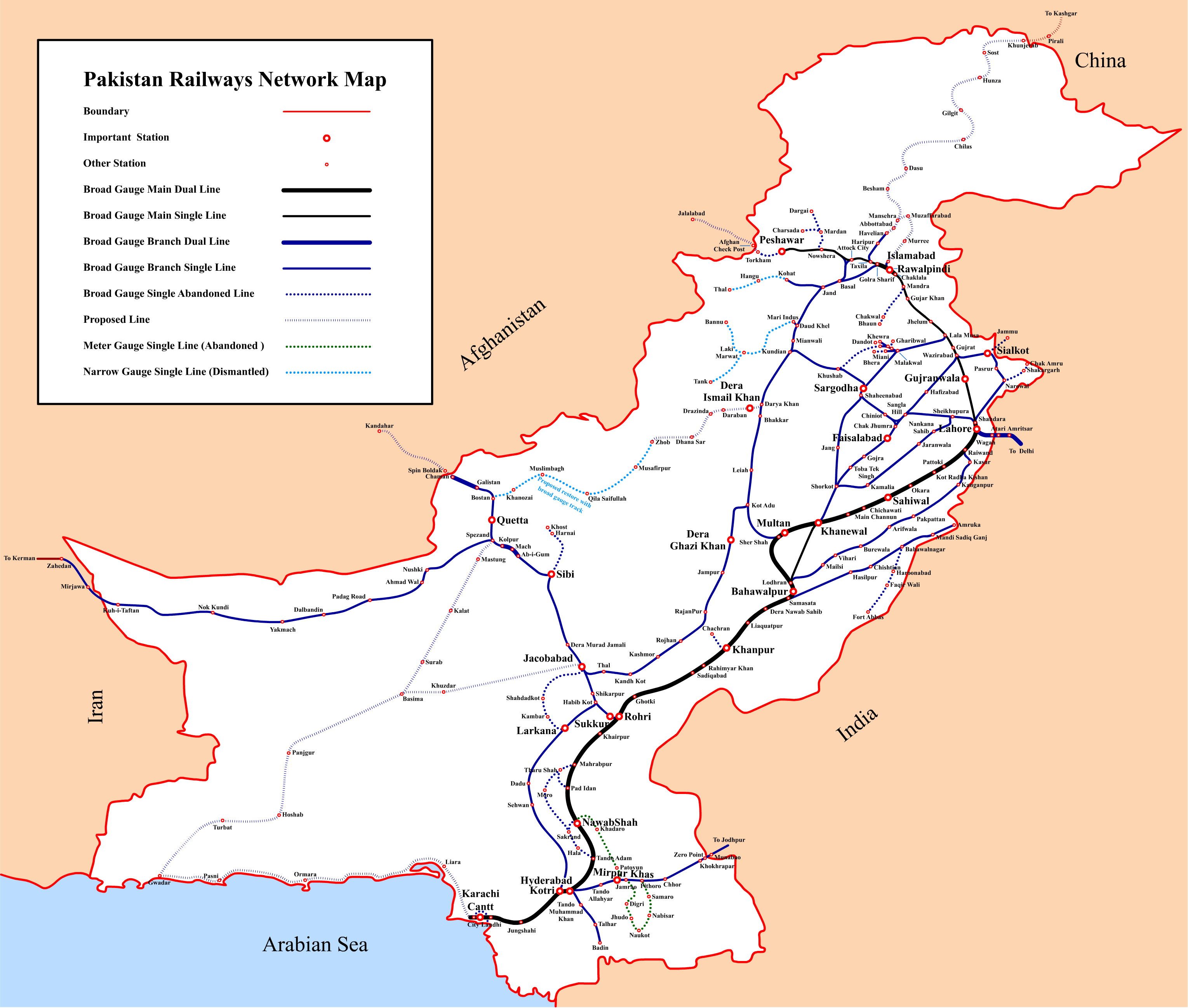
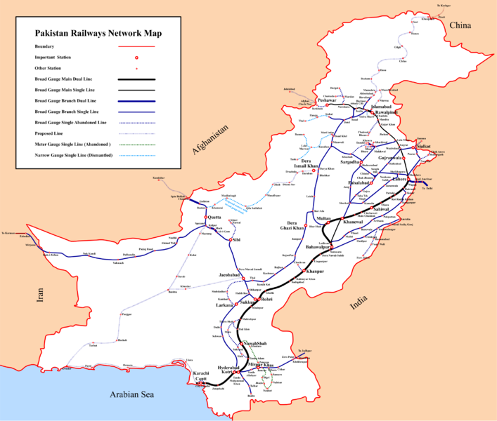
فائل:Pakistan Railways Network Map.png
ایں پیشگی ݙکھالے دا حجم:٧٠٧ × ٦٠٠ پکسلز ٻیاں قرارداداں: ٢٨٣ × ٢٤٠ پکسلز | ٥٦٦ × ٤٨٠ پکسلز | ٩٠٥ × ٧٦٨ پکسلز | ١,٢٠٧ × ١,٠٢٤ پکسلز | ٢,٤١٤ × ٢,٠٤٨ پکسلز | ٣,٠٥٩ × ٢,٥٩٥ پکسلز۔
اصل فائل (٣,٠٥٩ × ٢,٥٩٥ پکسل، فائل دا حجم: ٦٤٨ KB، MIME قسم: image/png)
خلاصہ
| Description |
English: Pakistan Railways Network Map |
|||||||||
| تریخ | ||||||||||
| ماخذ | اپݨا کام | |||||||||
| Creator | ||||||||||
| Geotemporal data | ||||||||||
| Bounding box |
|
|||||||||
| Georeferencing | ||||||||||
اجازہ کاری
I, the copyright holder of this work, hereby publish it under the following license:
ایں فائل کوں کریٹو کامنز Attribution 2.5 پولینڈ لائسنس ݙتا ڳیا.
- تساں آزاد ہو
- شیئر کرݨ – کم کوں کاپی نقل کرݨ، ونڈݨ یا کم کوں بھیجݨ کیتے
- وت رلاوݨ – کم کوں فٹ کرݨ
- تلویاں شرائط دے تحت:
- انتساب – جے تبدیلیاں تھیاں ہن تاں تساں مناسب کریڈیٹ ݙیوو، لائسنس کیتے لنک مہیا کرو تے اشارہ ݙیوو۔ تساں کہیں وی مناسب انداز وچ ایہ کر سڳدے ہو، پر ایں طرح ظاہر نہ تھیوے جو لائسنسر تہاکوں یا تہاݙے ورتاوے کوں انتساب کریندا پئے۔
- یکساں شراکت – جے تساں ولدا رَلیندے ہو، تبدیل کریندے ہو یا مواد تے اسریندے ہو تاں تہاکوں اصلی دے طور تے same or compatible license دے تحت آپݨیاں حصہ داریاں ونڈݨیاں پوسن۔
فائل دا تاریخچہ
کہیں خاص ویلے تے تریخ کوں فائل کین٘ویں نظردی ہائی، ݙیکھݨ کیتے اوں ویلے تے کلک کرو۔
| تریخ/ویلہ | تھمب نیل | پاسے | ورتݨ والا | رائے | |
|---|---|---|---|---|---|
| موجودہ | ٢٢:٤٩, ٣ ستمبر ٢٠١٦ | | ٣,٠٥٩ × ٢,٥٩٥ (٦٤٨ KB) | Adnanleon | Updated Karachi-Lahore dual railway track, Added Karachi-Gwadar, Islamabad-Muzaffarabad and Basima-Jacobabad proposed railway lines. |
| ١٦:٤٤, ٢٧ جنوری ٢٠١٤ |  | ٣,٠٣٢ × ٢,٥٧٢ (٥٩١ KB) | RaviC | + Jammu link | |
| ٠١:٥٤, ١ اگست ٢٠١٣ |  | ٣,٠٣٢ × ٢,٥٧٢ (٦٢٨ KB) | Adnanleon | Fill white color in center | |
| ٠١:٢٧, ١ اگست ٢٠١٣ |  | ٣,٠٣٢ × ٢,٥٧٢ (٥٦٠ KB) | Adnanleon | Correction in Sahiwal-Raiwind section and Pak-China proposed railway line | |
| ١٣:٢٧, ١ مارچ ٢٠١٢ |  | ٣,٠٤٢ × ٢,٥٥٧ (٥١٧ KB) | Nomi887 | Added colour (reason: to make map prominent) | |
| ٠٣:٢١, ٢٩ فروری ٢٠١٢ |  | ٣,٠٤٢ × ٢,٥٥٧ (٥٨٥ KB) | Sven Manguard | Removing time and author from image. This is *NOT* the version sent by OTRS, that one is immediately below. | |
| ٠٣:١٢, ٢٩ فروری ٢٠١٢ |  | ٣,٠٤٢ × ٢,٥٥٧ (٥٩٥ KB) | Sven Manguard | Update sent via OTRS photosubmissions | |
| ٢٣:٥٥, ٢٢ نومبر ٢٠١١ |  | ٣,٠١٠ × ٢,٥٤٠ (٤٦٦ KB) | Adnanleon |
فائل ورتݨ
اِیں فائل نال ہیٹھاں درج ورقہ مربوط ہے:
فائل دا کلجگ ورتاوا
ایہ ٻئے وکی ایں فائل کوں ورتیندن:
- bn.wikipedia.org تے ورتݨ
- de.wikipedia.org تے ورتݨ
- de.wikivoyage.org تے ورتݨ
- en.wikipedia.org تے ورتݨ
- en.wikivoyage.org تے ورتݨ
- eo.wikipedia.org تے ورتݨ
- fr.wikipedia.org تے ورتݨ
- hi.wikipedia.org تے ورتݨ
- hu.wikipedia.org تے ورتݨ
- it.wikivoyage.org تے ورتݨ
- ja.wikipedia.org تے ورتݨ
- mr.wikipedia.org تے ورتݨ
- pl.wikipedia.org تے ورتݨ
- pnb.wikipedia.org تے ورتݨ
ایں فائل دا ٻیا جگ ورتݨ ݙیکھو.