
فائل:Cyprus districts named.png
ایں کنوں ودھ ریزولیوشن دستیاب کائنی۔
Cyprus_districts_named.png (٦٠٠ × ٣٦٥ پکسل، فائل دا حجم: ٢٢ KB، MIME قسم: image/png)

|
This map image could be re-created using vector graphics as an SVG file. This has several advantages; see Commons:Media for cleanup for more information. If an SVG form of this image is available, please upload it and afterwards replace this template with
{{vector version available|new image name}}.
It is recommended to name the SVG file “Cyprus districts named.svg”—then the template Vector version available (or Vva) does not need the new image name parameter. |
خلاصہ
| تفصیل |
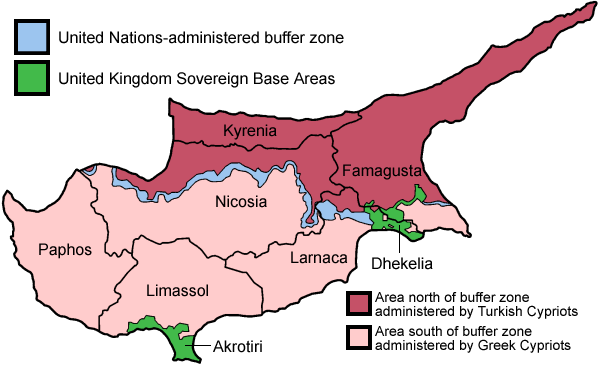
English: Map of the districts of Cyprus, named in English, with English annotations, and showing the Turkish Republic of Northern Cyprus, United Kingdom Sovereign Base Areas, and United Nations buffer zone. The individual maps see below.
Deutsch: Karte der Distrikte Zyperns: Bezirke der Republik Zypern, Türkische Republik Nordzypern, UK-Militärbasen, UN-Pufferzone (englische Beschriftung). Zu den Einzelkarten siehe unten "Individual maps". |
| تریخ | |
| ماخذ | اپݨا کام (traced from public domain UN or CIA maps.) |
| مصنف | Golbez |
| Other versions |
Français : File:Carte des districts de Chypre.png
Ελληνικά: File:Cyprus districts named el.png
|
اجازہ کاری
I, the copyright holder of this work, hereby publish it under the following licenses:
This file is licensed under the Creative Commons Attribution-Share Alike 2.5 Generic, 2.0 Generic and 1.0 Generic license.
- تساں آزاد ہو
- شیئر کرݨ – کم کوں کاپی نقل کرݨ، ونڈݨ یا کم کوں بھیجݨ کیتے
- وت رلاوݨ – کم کوں فٹ کرݨ
- تلویاں شرائط دے تحت:
- انتساب – جے تبدیلیاں تھیاں ہن تاں تساں مناسب کریڈیٹ ݙیوو، لائسنس کیتے لنک مہیا کرو تے اشارہ ݙیوو۔ تساں کہیں وی مناسب انداز وچ ایہ کر سڳدے ہو، پر ایں طرح ظاہر نہ تھیوے جو لائسنسر تہاکوں یا تہاݙے ورتاوے کوں انتساب کریندا پئے۔
- یکساں شراکت – جے تساں ولدا رَلیندے ہو، تبدیل کریندے ہو یا مواد تے اسریندے ہو تاں تہاکوں اصلی دے طور تے same or compatible license دے تحت آپݨیاں حصہ داریاں ونڈݨیاں پوسن۔

|
تہاکوں آزاد سافٹ ویئر فاؤنڈیشن ولوں شائع تھئی جی این یو آزاد مسوداتی اجازت نامہ دیاں شرائط استعمال دے تحت ایں دستاویز کوں نقل، تقسیم اتے/ یا ترمیم کرݨ دی اجازت ݙتی ویندی ہے۔ ایں اجازت نامہ دی ہک نقل 'جی این یو آزاد مسوداتی اجازت نامہ دے عنوان نال میسر ہے۔ |
| ایں فائل کوں کریٹو کامنز Attribution 2.5 پولینڈ لائسنس ݙتا ڳیا. | ||
| ||
| This licensing tag was added to this file as part of the GFDL licensing update. |
تساں آپݨی مرضی دا لائسنس چُݨ سڳدے ہو
Individual maps of the Cyprus districts
فائل دا تاریخچہ
کہیں خاص ویلے تے تریخ کوں فائل کین٘ویں نظردی ہائی، ݙیکھݨ کیتے اوں ویلے تے کلک کرو۔
| تریخ/ویلہ | تھمب نیل | پاسے | ورتݨ والا | رائے | |
|---|---|---|---|---|---|
| موجودہ | ٠١:٣٨, ٣١ مئی ٢٠١٠ | | ٦٠٠ × ٣٦٥ (٢٢ KB) | Wknight94 | Reverted to version as of 14:28, 13 August 2007 ---- latest upload with no new info on source, etc. |
| ٠٤:٤٦, ١٨ نومبر ٢٠٠٨ |  | ٧٠٠ × ٤٨٢ (٩٤ KB) | Guntars strazdins | {{Information |Description= |Source= |Date= |Author= |Permission= |other_versions= }} | |
| ٠٤:٤٤, ١٨ نومبر ٢٠٠٨ |  | ٧٠٠ × ٤٨٢ (٩٤ KB) | Guntars strazdins | {{Information |Description= |Source= |Date= |Author= |Permission= |other_versions= }} | |
| ١٩:٢٨, ١٣ اگست ٢٠٠٧ |  | ٦٠٠ × ٣٦٥ (٢٢ KB) | Lexicon | Reverted to earlier revision | |
| ١٩:٢٨, ١٣ اگست ٢٠٠٧ |  | ٦٠٠ × ٣٦٥ (٥٤ KB) | Lexicon | buffer zone and SBA colours flipped, since buffer zone is called the "Green Line" | |
| ١١:٠٧, ٣٠ جون ٢٠٠٥ |  | ٦٠٠ × ٣٦٥ (٢٢ KB) | Golbez | Got Dhekelia wrong again. Final version unless others have comments. | |
| ٠٧:٠٤, ٢٨ جون ٢٠٠٥ |  | ٦٠٠ × ٣٦٥ (٢٢ KB) | Golbez | Updated again, final version for now, cleaned up text and the Dhekelia area. | |
| ٢٢:٥١, ٢٧ جون ٢٠٠٥ |  | ٦٠٠ × ٣٦٥ (٢٠ KB) | Golbez | Fixed a color | |
| ٢٢:٤٤, ٢٧ جون ٢٠٠٥ |  | ٦٠٠ × ٣٦٥ (٢٠ KB) | Golbez | Updated map with different color for north and south, and enclaves in Dhekelia. | |
| ١٤:٤٨, ٢٧ جون ٢٠٠٥ |  | ٦٠٠ × ٣٦٥ (١٩ KB) | Golbez | Map of the districts of Cyprus Source: Made by User:Golbez. {{cc-by-sa-2.0}} Category:Maps of Cyprus\ |
فائل ورتݨ
اِیں فائل نال ہیٹھاں درج 3 صفحات مربوط ہن:
فائل دا کلجگ ورتاوا
ایہ ٻئے وکی ایں فائل کوں ورتیندن:
- af.wikipedia.org تے ورتݨ
- ar.wikipedia.org تے ورتݨ
- arz.wikipedia.org تے ورتݨ
- az.wikipedia.org تے ورتݨ
- az.wiktionary.org تے ورتݨ
- be.wikipedia.org تے ورتݨ
- bs.wikipedia.org تے ورتݨ
- ca.wikipedia.org تے ورتݨ
- Conflicte de Xipre
- Resolució 187 del Consell de Seguretat de les Nacions Unides
- Resolució 192 del Consell de Seguretat de les Nacions Unides
- Resolució 193 del Consell de Seguretat de les Nacions Unides
- Resolució 194 del Consell de Seguretat de les Nacions Unides
- Resolució 198 del Consell de Seguretat de les Nacions Unides
- Resolució 201 del Consell de Seguretat de les Nacions Unides
- Resolució 206 del Consell de Seguretat de les Nacions Unides
- Resolució 207 del Consell de Seguretat de les Nacions Unides
- Resolució 219 del Consell de Seguretat de les Nacions Unides
- Resolució 220 del Consell de Seguretat de les Nacions Unides
- Resolució 222 del Consell de Seguretat de les Nacions Unides
- Resolució 231 del Consell de Seguretat de les Nacions Unides
- Resolució 244 del Consell de Seguretat de les Nacions Unides
- Resolució 254 del Consell de Seguretat de les Nacions Unides
- Resolució 266 del Consell de Seguretat de les Nacions Unides
- Resolució 274 del Consell de Seguretat de les Nacions Unides
- Força de les Nacions Unides pel Manteniment de la Pau a Xipre
- Resolució 293 del Consell de Seguretat de les Nacions Unides
- Resolució 305 del Consell de Seguretat de les Nacions Unides
- Resolució 315 del Consell de Seguretat de les Nacions Unides
- Resolució 324 del Consell de Seguretat de les Nacions Unides
- Resolució 334 del Consell de Seguretat de les Nacions Unides
- Resolució 343 del Consell de Seguretat de les Nacions Unides
- Resolució 349 del Consell de Seguretat de les Nacions Unides
- Resolució 358 del Consell de Seguretat de les Nacions Unides
- Resolució 360 del Consell de Seguretat de les Nacions Unides
- Resolució 361 del Consell de Seguretat de les Nacions Unides
- Resolució 364 del Consell de Seguretat de les Nacions Unides
- Resolució 365 del Consell de Seguretat de les Nacions Unides
- Línia Verda (Xipre)
- Resolució 593 del Consell de Seguretat de les Nacions Unides
- Resolució 716 del Consell de Seguretat de les Nacions Unides
- Resolució 774 del Consell de Seguretat de les Nacions Unides
- Resolució 969 del Consell de Seguretat de les Nacions Unides
- Resolució 1475 del Consell de Seguretat de les Nacions Unides
- Resolució 1517 del Consell de Seguretat de les Nacions Unides
- ckb.wikipedia.org تے ورتݨ
ایں فائل دا ٻیا جگ ورتݨ ݙیکھو.