
فائل:Roman expansion 264 BC Shepherd.jpg

اصل فائل (٢,٣٠٢ × ١,٨١٢ پکسل، فائل دا حجم: ٨٧٣ KB، MIME قسم: image/jpeg)
This image was copied from wikipedia:de. The original description was:
| تفصیل |
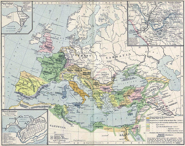
English: Roman territory, from the beginning of the 1st punic war (264 B.C.) to the death of Diocletian
Deutsch: Römisches Reich vom Beginn des 1. Punischen Kriegs (264 v.Chr.) bis zum Tod von Diokletian (312) im Historischen Atlas von William R. Shepherd (1923) |
| تریخ | 1923 |
| ماخذ | "Historical Atlas" by William R. Shepherd, New York, Henry Holt and Company |
| مصنف | William R. Shepherd |
| Other versions |
|
This work is in the public domain in its country of origin and other countries and areas where the copyright term is the author's life plus 70 years or fewer.
| |
| This file has been identified as being free of known restrictions under copyright law, including all related and neighboring rights. | |
| date/time | username | edit summary |
|---|---|---|
| 18:08, 21. Feb 2005 | Benowar | ("Historical Atlas" by William R. Shepherd, New York, Henry Holt and Company, 1923 PUBLIC DOMAIN) |
فائل دا تاریخچہ
کہیں خاص ویلے تے تریخ کوں فائل کین٘ویں نظردی ہائی، ݙیکھݨ کیتے اوں ویلے تے کلک کرو۔
| تریخ/ویلہ | تھمب نیل | پاسے | ورتݨ والا | رائے | |
|---|---|---|---|---|---|
| موجودہ | ٢٢:٠٨, ١٨ اپريل ٢٠٠٦ | | ٢,٣٠٢ × ١,٨١٢ (٨٧٣ KB) | Crux | verbesserte Version |
| ٢١:٥٣, ١٨ اپريل ٢٠٠٦ |  | ٢,٣٠٢ × ١,٨١٢ (٧٦٧ KB) | Crux | This image was copied from wikipedia:de. The original description was: {{Information| |Description=Roman territory at the beginning of the 1st punic war (264 B.C.) |Source="Historical Atlas" by William R. Shepherd, New York, Henry Holt and Company |Date= |
فائل ورتݨ
اِیں فائل نال ہیٹھاں درج ورقہ مربوط ہے:
فائل دا کلجگ ورتاوا
ایہ ٻئے وکی ایں فائل کوں ورتیندن:
- ast.wikipedia.org تے ورتݨ
- ba.wikipedia.org تے ورتݨ
- bn.wikipedia.org تے ورتݨ
- br.wikipedia.org تے ورتݨ
- ca.wikipedia.org تے ورتݨ
- de.wikipedia.org تے ورتݨ
- de.wikibooks.org تے ورتݨ
- en.wikipedia.org تے ورتݨ
- es.wikipedia.org تے ورتݨ
- fr.wikipedia.org تے ورتݨ
- fy.wikipedia.org تے ورتݨ
- it.wikipedia.org تے ورتݨ
- it.wikibooks.org تے ورتݨ
- lv.wikipedia.org تے ورتݨ
- mk.wikipedia.org تے ورتݨ
- mwl.wikipedia.org تے ورتݨ
- pnb.wikipedia.org تے ورتݨ
- pt.wikipedia.org تے ورتݨ
- ru.wikipedia.org تے ورتݨ
- sa.wikipedia.org تے ورتݨ
- sk.wikipedia.org تے ورتݨ
- sl.wikipedia.org تے ورتݨ
- sq.wikipedia.org تے ورتݨ
- ur.wikipedia.org تے ورتݨ
- vi.wikipedia.org تے ورتݨ
- zh.wikipedia.org تے ورتݨ