فائل:Nile River and delta from orbit.jpg

Page contents not supported in other languages.
وکیپیڈیا توں

Nile_River_and_delta_from_orbit.jpg(٧٠٠ × ٥٥٠ پکسل، فائل دا حجم: ٨٥ KB، MIME قسم: image/jpeg)

ایہ فائل Wikimedia Commons توں ہے تے ݙوجھیاں منصوبیاں تے وی ورتی ویسی۔ ایندی وضاحت فائل دی وضاحت دا ورقہ تے تھلے ݙتی ڳئی۔

خلاصہ

تفصیل

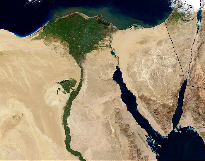
Nile River and delta from orbit Description: The Nile River and delta as seen from space by the MODIS sensor on the Terra satellite.

"Against the barren desert of northeastern Africa, the fertile valley of the Nile River runs northward through Egypt. In the higher-resolution images, the city of Cairo can be seen as a gray smudge right where the river widens into its broad fan-shaped delta. Other cities are dotted across the green landscape, giving it a speckled appearance. Where the Nile empties into the Mediterranean Sea (top) the waters are swirling with color, likely a mixture of sediment, organic matter, and possibly marine plant life. Farther west, the bright blue color of the water is likely less-organically rich sediment, perhaps sand.
"East of the delta lies the arid Sinai Peninsula, whose pointed tip is home to rugged mountains, some as high as 8,600 feet. The lattice work of pale lines marks the paths of ephemeral rivers. The Sinai Peninsula intrudes into the Red Sea. Farther east are Israel, Jordan, and Saudi Arabia. At top right is the disputed territory of the West Bank.
"In the false-color image, vegetation is bright green, water is dark blue or black, and clouds are light blue. It's interesting to notice that places that seem essentially arid, or desert-like in the true-color image in fact have a delicate layer of vegetation. For example, the central Sinai Peninsula, and most of Israel have a faint greenish tinge in the false-color images.
تریخ
ماخذ http://visibleearth.nasa.gov/view_rec.php?id=4927 [1]
مصنف Jacques Descloitres, MODIS Rapid Response Team, NASA/sh
Other versions Cuaggjacgacugvajgca

Salchicha

اجازہ کاری

Public domain This file is in the public domain in the United States because it was solely created by NASA. NASA copyright policy states that "NASA material is not protected by copyright unless noted". (See Template:PD-USGov, NASA copyright policy page or JPL Image Use Policy.)
Warnings:

عنوان

Add a one-line explanation of what this file represents
Nile delta

Items portrayed in this file

depicts سرائیکی ► skr

inception سرائیکی ► skr

٥ فروری 2003

media type سرائیکی ► skr

image/jpeg

فائل دا تاریخچہ

کہیں خاص ویلے تے تریخ کوں فائل کین٘ویں نظردی ہائی، ݙیکھݨ کیتے اوں ویلے تے کلک کرو۔

تریخ/ویلہتھمب نیلپاسےورتݨ والارائے
موجودہ٠٣:٤٧, ٣٠ نومبر ٢٠٠٤مورخہ ٠٣:٤٧, ٣٠ نومبر ٢٠٠٤ دا تھمب نیل٧٠٠ × ٥٥٠ (٨٥ KB)MschlindweinNile River and delta from orbit

اِیں فائل نال ہیٹھاں درج ورقہ مربوط ہے:

فائل دا کلجگ ورتاوا

ایہ ٻئے وکی ایں فائل کوں ورتیندن:

ایں فائل دا ٻیا جگ ورتݨ ݙیکھو.