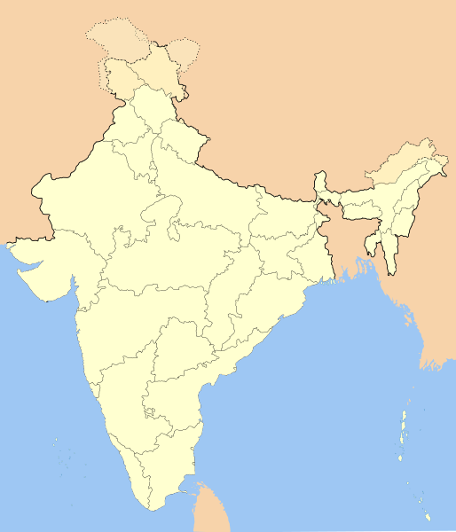
فائل:India-locator-map-blank.svg

Size of this PNG preview of this SVG file: ٥١٤ × ٦٠٠ پکسلز. ٻیاں قرارداداں: ٢٠٦ × ٢٤٠ پکسلز | ٤١١ × ٤٨٠ پکسلز | ٦٥٨ × ٧٦٨ پکسلز | ٨٧٧ × ١,٠٢٤ پکسلز | ١,٧٥٥ × ٢,٠٤٨ پکسلز | ١,٤٨٦ × ١,٧٣٤ پکسلز۔
اصل فائل (ایس وی جی فائل، ابعاد ١,٤٨٦ × ١,٧٣٤ پکسل، فائل دا حجم: ٢٥٢ KB)
فائل دا تاریخچہ
کہیں خاص ویلے تے تریخ کوں فائل کین٘ویں نظردی ہائی، ݙیکھݨ کیتے اوں ویلے تے کلک کرو۔
| تریخ/ویلہ | تھمب نیل | پاسے | ورتݨ والا | رائے | |
|---|---|---|---|---|---|
| موجودہ | ١٩:٠١, ١٤ اکتوبر ٢٠٢٠ |  | ١,٤٨٦ × ١,٧٣٤ (٢٥٢ KB) | NordNordWest | upd Telangana/Andhra Pradesh |
| ٢٢:٤٨, ٢٥ جولائی ٢٠٢٠ |  | ١,٤٨٦ × ١,٧٣٤ (٢٥٢ KB) | NordNordWest | Jammu and Kashmir/Ladakh | |
| ٠٦:٤٢, ١ اپريل ٢٠١٧ |  | ١,٤٨٦ × ١,٧٣٤ (٣٣٧ KB) | Utcursch | Moved Telangana to states layer | |
| ١٩:٠٨, ٢٩ جنوری ٢٠١٦ |  | ١,٤٨٦ × ١,٧٣٤ (٣٧٩ KB) | Csyogi | Telangana update | |
| ٢٠:٣٦, ١٦ مئی ٢٠٠٦ |  | ١,٤٨٦ × ١,٧٣٤ (٤٢١ KB) | Nichalp | Siachen edits | |
| ١٧:٤٩, ١٣ مئی ٢٠٠٦ |  | ١,٤٨٦ × ١,٧٣٤ (٤٢٤ KB) | Nichalp | Siachen correction | |
| ١٧:٤٣, ١٣ مئی ٢٠٠٦ |  | ١,٤٨٦ × ١,٧٣٤ (٤٢٢ KB) | Nichalp | border changes | |
| ١٠:٥٣, ٩ مئی ٢٠٠٦ |  | ١,٤٨٦ × ١,٧٣٤ (٤٢١ KB) | Nichalp | Updates as suggested in FPC | |
| ١٢:٤٨, ٧ مئی ٢٠٠٦ |  | ١,٤٨٦ × ١,٧٣٤ (٤٢١ KB) | Nichalp | Version 2; added some additional disputed areas in the Western sector | |
| ٢٣:٢٧, ٦ مئی ٢٠٠٦ |  | ١,٤٨٦ × ١,٧٣٤ (٤١٦ KB) | Nichalp | Blank locator map of India SVG Map drawn by me, ~~~~ category:Maps of India |
فائل ورتݨ
ایں فائل نال کوئی ورقہ کائنی ڄُڑیا ہویا۔
فائل دا کلجگ ورتاوا
ایہ ٻئے وکی ایں فائل کوں ورتیندن:
- as.wikipedia.org تے ورتݨ
- as.wikiquote.org تے ورتݨ
- awa.wikipedia.org تے ورتݨ
- खाँचा:ज्ञानसन्दूक भारत कय क्षेत्र
- भारत कय राज्य
- भारत कय संघ राज्यक्षेत्र
- खाँचा:India States and Territories Labelled Map
- खाँचा:Infobox Indian Jurisdiction
- खाँचा:Infobox Indian Jurisdiction/Examples/city
- खाँचा:Infobox Indian Jurisdiction/Examples/district
- खाँचा:Infobox Indian Jurisdiction/Examples/neighbourhood
- खाँचा:Infobox Indian Jurisdiction/Examples/protected area
- खाँचा:Infobox Indian Jurisdiction/Examples/state
- खाँचा:Infobox Indian Jurisdiction/Examples/suburb
- खाँचा:Infobox Indian Jurisdiction/Examples/town
- खाँचा:Infobox Indian Jurisdiction/Examples/village
- खाँचा:Infobox Indian Jurisdiction/Sandbox
- खाँचा:Infobox Indian Jurisdiction/Sandbox/doc
- खाँचा:Infobox Indian Jurisdiction/doc
- खाँचा:ज्ञानसन्दूक भारत कय क्षेत्र/doc
- सीधी
- ban.wikipedia.org تے ورتݨ
- bn.wikipedia.org تے ورتݨ
- bpy.wikipedia.org تے ورتݨ
ایں فائل دا ٻیا جگ ورتݨ ݙیکھو.


