
فائل:Europe in 1430.PNG
ایں پیشگی ݙکھالے دا حجم:٥٥٣ × ٥٩٩ پکسلز ٻیاں قرارداداں: ٢٢١ × ٢٤٠ پکسلز | ٦٠٠ × ٦٥٠ پکسلز۔
اصل فائل (٦٠٠ × ٦٥٠ پکسل، فائل دا حجم: ٦٩ KB، MIME قسم: image/png)
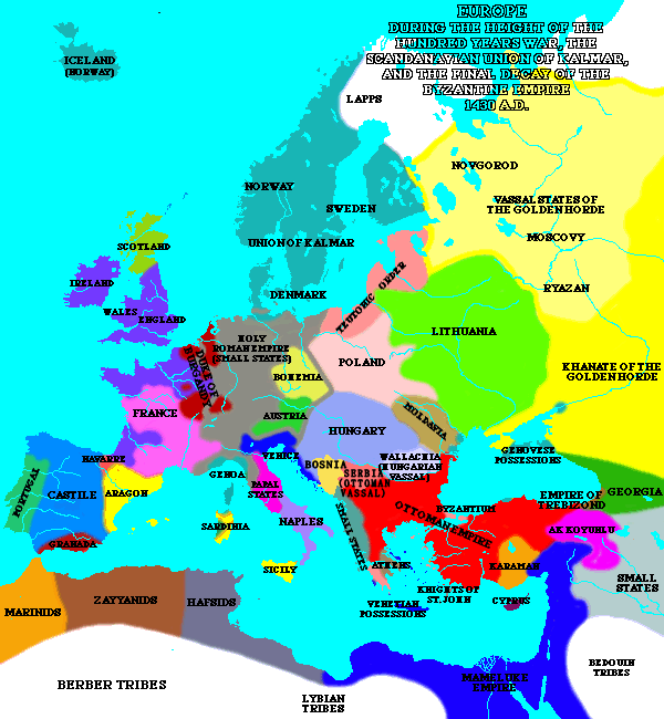
| تفصیل | A map of Europe in 1430. | ||
| ماخذ | [1] | ||
| مصنف | Lynn H. Nelson | ||
| اجازت (فائل دا دوبارہ استعمال) |
|
_en.png)
.png)
.jpg)
فائل دا تاریخچہ
کہیں خاص ویلے تے تریخ کوں فائل کین٘ویں نظردی ہائی، ݙیکھݨ کیتے اوں ویلے تے کلک کرو۔
| تریخ/ویلہ | تھمب نیل | پاسے | ورتݨ والا | رائے | |
|---|---|---|---|---|---|
| موجودہ | ٠١:١٦, ١١ مئی ٢٠٢٠ | | ٦٠٠ × ٦٥٠ (٦٩ KB) | Santasa99 | Per John V.A. Fine: The Late Medieval Balkans: A Critical Survey from the Late Twelfth Century to the Ottoman Conquest; Chapter 9. The Balkans in the Early Fifteenth Century - Bosnia after death of Tvrtko |
| ٠٠:٣٠, ٩ مارچ ٢٠٠٥ |  | ٦٠٠ × ٦٥٠ (٤٤ KB) | Quadell | A map of Europe in 1430.{{PD}}Source:[http://www.ku.edu/kansas/medieval/108/lectures/]Category:Maps of EuropeCategory:Historical mapsCategory:1430 |
فائل ورتݨ
اِیں فائل نال ہیٹھاں درج ورقہ مربوط ہے:
فائل دا کلجگ ورتاوا
ایہ ٻئے وکی ایں فائل کوں ورتیندن:
- ar.wikipedia.org تے ورتݨ
- az.wikipedia.org تے ورتݨ
- ba.wikipedia.org تے ورتݨ
- bg.wikipedia.org تے ورتݨ
- bn.wikipedia.org تے ورتݨ
- bxr.wikipedia.org تے ورتݨ
- ca.wikipedia.org تے ورتݨ
- cs.wikipedia.org تے ورتݨ
- de.wikipedia.org تے ورتݨ
- el.wikipedia.org تے ورتݨ
- en.wikipedia.org تے ورتݨ
- en.wikibooks.org تے ورتݨ
- es.wikipedia.org تے ورتݨ
- fa.wikipedia.org تے ورتݨ
- fi.wikipedia.org تے ورتݨ
- fr.wikipedia.org تے ورتݨ
- id.wikipedia.org تے ورتݨ
- io.wikipedia.org تے ورتݨ
- is.wikipedia.org تے ورتݨ
- ka.wikipedia.org تے ورتݨ
- mk.wikipedia.org تے ورتݨ
- nds-nl.wikipedia.org تے ورتݨ
- nl.wikipedia.org تے ورتݨ
- nn.wikipedia.org تے ورتݨ
- no.wikipedia.org تے ورتݨ
- pnb.wikipedia.org تے ورتݨ
- pt.wikipedia.org تے ورتݨ
- ru.wikipedia.org تے ورتݨ
- sa.wikipedia.org تے ورتݨ
- scn.wikipedia.org تے ورتݨ
- sh.wikipedia.org تے ورتݨ
- simple.wikipedia.org تے ورتݨ
- sk.wikipedia.org تے ورتݨ
ایں فائل دا ٻیا جگ ورتݨ ݙیکھو.