
فائل:Europa 1890.jpg

ایں پیشگی ݙکھالے دا حجم:٧٦٦ × ٥٩٩ پکسلز ٻیاں قرارداداں: ٣٠٧ × ٢٤٠ پکسلز | ٦١٤ × ٤٨٠ پکسلز | ٩٨٢ × ٧٦٨ پکسلز | ١,٢٨٠ × ١,٠٠١ پکسلز | ٢,٥٠٠ × ١,٩٥٦ پکسلز۔
اصل فائل (٢,٥٠٠ × ١,٩٥٦ پکسل، فائل دا حجم: ١.٨٤ MB، MIME قسم: image/jpeg)
خلاصہ
| Description |
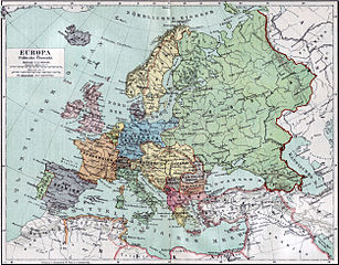
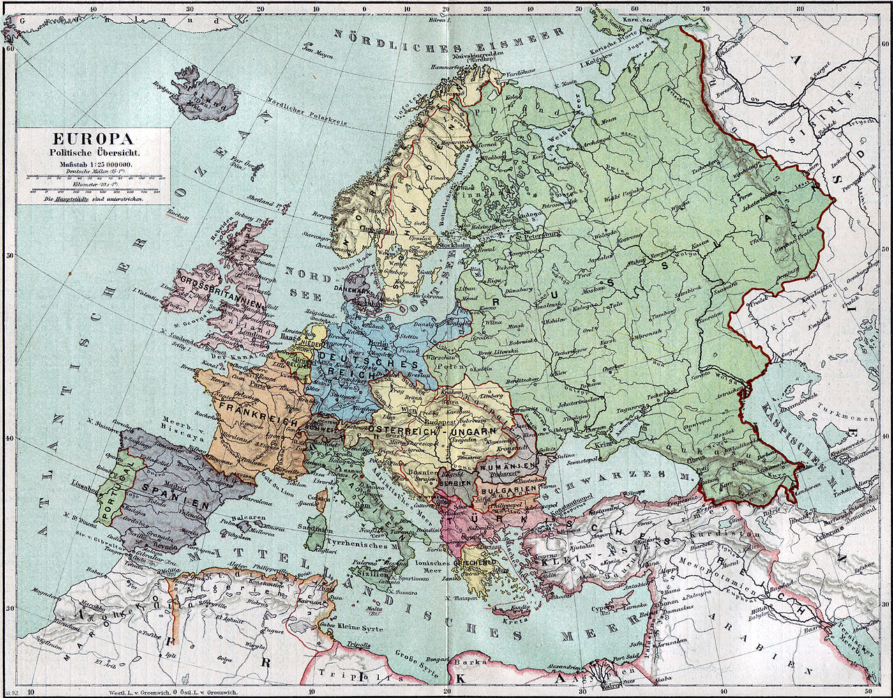
Politische Karte Europas ca. 1890 |
|||||
| تریخ | ||||||
| ماخذ | Meyers Kleines Konversationslexikon. Fünfte, umgearbeitete und vermehrte Auflage. Bd. 1. Bibliographisches Institut, Leipzig und Wien 1892. | |||||
| Creator |
unbekannt, scan by sidonius 15:36, 7 November 2006 (UTC) |
|||||
| اجازت (فائل دا دوبارہ استعمال) |
|
|||||
| Georeferencing | If inappropriate please set warp_status = skip to hide. | |||||
| Other versions | Derivative works of this file: Blank map of Europe 1890.svg |

_en.png)
.png)
.jpg)
فائل دا تاریخچہ
کہیں خاص ویلے تے تریخ کوں فائل کین٘ویں نظردی ہائی، ݙیکھݨ کیتے اوں ویلے تے کلک کرو۔
| تریخ/ویلہ | تھمب نیل | پاسے | ورتݨ والا | رائے | |
|---|---|---|---|---|---|
| موجودہ | ٢٠:٣٦, ٧ نومبر ٢٠٠٦ | | ٢,٥٠٠ × ١,٩٥٦ (١.٨٤ MB) | Sidonius | {{Information |Description=Politische Karte Europas ca. 1890 |Source=Meyers Kleines Konversationslexikon. Fünfte, umgearbeitete und vermehrte Auflage. Bd. 1. Bibliographisches Institut, Leipzig und Wien 1892. |Date=1892 |Author=unbekannt, |
فائل ورتݨ
اِیں فائل نال ہیٹھاں درج ورقہ مربوط ہے:
فائل دا کلجگ ورتاوا
ایہ ٻئے وکی ایں فائل کوں ورتیندن:
- bn.wikipedia.org تے ورتݨ
- de.wikipedia.org تے ورتݨ
- de.wikibooks.org تے ورتݨ
- en.wikipedia.org تے ورتݨ
- et.wikipedia.org تے ورتݨ
- fa.wikipedia.org تے ورتݨ
- fr.wikipedia.org تے ورتݨ
- hu.wikipedia.org تے ورتݨ
- it.wikipedia.org تے ورتݨ
- mk.wikipedia.org تے ورتݨ
- pl.wikipedia.org تے ورتݨ
- pnb.wikipedia.org تے ورتݨ
- sa.wikipedia.org تے ورتݨ
- scn.wikipedia.org تے ورتݨ
- uk.wikipedia.org تے ورتݨ
- ur.wikipedia.org تے ورتݨ