
فائل:Etruscan civilization map.png

ایں پیشگی ݙکھالے دا حجم:٤٩٣ × ٥٩٩ پکسلز ٻیاں قرارداداں: ١٩٧ × ٢٤٠ پکسلز | ٣٩٥ × ٤٨٠ پکسلز | ٩٩٤ × ١,٢٠٨ پکسلز۔
اصل فائل (٩٩٤ × ١,٢٠٨ پکسل، فائل دا حجم: ٣٦١ KB، MIME قسم: image/png)
خلاصہ
| تفصیل |
[]
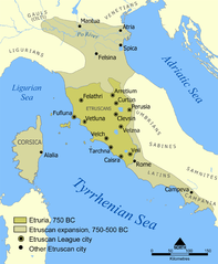
Català: Un mapa que mostra l'extensió d'Etruria i la civilització etrusca. El mapa inclou les 12 ciutats de la Lliga Etrusca i ciutats notables fundades pels etruscs. Les dates del mapa són una aproximació. English: A map showing the extent of Etruria and the Etruscan civilization. The map includes the 12 cities of the Etruscan League and notable cities founded by the Etruscans. The dates on the map are an approximation. Español: Expansión etrusca entre el 750 y el 500 a. de C., las ciudades de la Liga etrusca y otras notables fundadas por los etruscos. Português: Mapa da expansão etrusca entre 750-500 Suomi: Kartta Etruriasta ja etruskien sivilisaatiosta sen ollessa laajimmillaan. Karttaan on merkitty etruskien kaupunkiliiton 12 kaupunkia sekä muita etruskien perustamia merkittäviä kaupunkeja. Ελληνικά: Χάρτης της Ετρουρίας Беларуская: Карта паказвае абрысы Этрурыі і этрускай цывілізацыі. Яна ўключае 12 асноўных гарадоў этрускай лігі і іншыя горады, заснаваныя этрускамі. ქართული: ეტრუსკული ცივილიზაციის რუკა. עברית : מפה המציגה את היקף אטרוריה והציוויליזציה האטרוסקית. המפה כוללת את 12 ערי הליגה האטרוסקית וערים בולטות שנוסדו על ידי האטרוסקים. התאריכים במפה הם בקירוב. العربية : خريطة تُظهر نطاق الحضارتين الإترورياويَّة والإتروسكانيَّة. تتضمَّن هذه الخريطة 12 مدينة انتمت إلى الرابطة الإتروسكانيَّة ومُدن مُهمَّة وبارزة أُخرى كانت قائمة ضمن بلاد الإتروسكان. |
||
| تریخ | |||
| ماخذ | Based on a map from The National Geographic Magazine Vol.173 No.6 June 1988. | ||
| مصنف | NormanEinstein | ||
| اجازت (فائل دا دوبارہ استعمال) |
GNU-FDL | ||
| Other versions |
[]
|


اجازہ کاری
I, the copyright holder of this work, hereby publish it under the following licenses:

|
تہاکوں آزاد سافٹ ویئر فاؤنڈیشن ولوں شائع تھئی جی این یو آزاد مسوداتی اجازت نامہ دیاں شرائط استعمال دے تحت ایں دستاویز کوں نقل، تقسیم اتے/ یا ترمیم کرݨ دی اجازت ݙتی ویندی ہے۔ ایں اجازت نامہ دی ہک نقل 'جی این یو آزاد مسوداتی اجازت نامہ دے عنوان نال میسر ہے۔ |
| ایں فائل کوں کریٹو کامنز Attribution 2.5 پولینڈ لائسنس ݙتا ڳیا. | ||
| ||
| This licensing tag was added to this file as part of the GFDL licensing update. |
تساں آپݨی مرضی دا لائسنس چُݨ سڳدے ہو
فائل دا تاریخچہ
کہیں خاص ویلے تے تریخ کوں فائل کین٘ویں نظردی ہائی، ݙیکھݨ کیتے اوں ویلے تے کلک کرو۔
| تریخ/ویلہ | تھمب نیل | پاسے | ورتݨ والا | رائے | |
|---|---|---|---|---|---|
| موجودہ | ١٧:١٨, ٢٢ جولائی ٢٠١٠ | | ٩٩٤ × ١,٢٠٨ (٣٦١ KB) | Ras67 | cropped |
| ٠١:١٠, ٧ فروری ٢٠٠٦ |  | ١,٠٠٠ × ١,٢١٤ (٥٢٥ KB) | NormanEinstein | Modified tribe names. | |
| ١٩:٠١, ٢٧ جولائی ٢٠٠٥ |  | ٨٠٠ × ٩٧١ (٤٠٥ KB) | NormanEinstein | Corrected several typos. | |
| ٠٢:٠٣, ٢٧ جولائی ٢٠٠٥ |  | ٨٠٠ × ٩٧١ (٤١٦ KB) | NormanEinstein | A map showing the extent of Etruria and the Etruscan civilization. The map includes the 12 cities of the Etruscan League and notable cities founded by the Etruscans. Created by NormanEinstein, July 26, 2005. {{GFDL-self}} |
فائل ورتݨ
اِیں فائل نال ہیٹھاں درج ورقہ مربوط ہے:
فائل دا کلجگ ورتاوا
ایہ ٻئے وکی ایں فائل کوں ورتیندن:
- af.wikipedia.org تے ورتݨ
- ar.wikipedia.org تے ورتݨ
- ast.wikipedia.org تے ورتݨ
- azb.wikipedia.org تے ورتݨ
- az.wikipedia.org تے ورتݨ
- bg.wikipedia.org تے ورتݨ
- bh.wikipedia.org تے ورتݨ
- cs.wikipedia.org تے ورتݨ
- cy.wikipedia.org تے ورتݨ
- da.wikipedia.org تے ورتݨ
- de.wikipedia.org تے ورتݨ
- en.wikipedia.org تے ورتݨ
- Etruscan language
- Etruscan civilization
- Etruria
- 800 BC
- Classical antiquity
- Campaign history of the Roman military
- User:NormanEinstein
- Caere
- Battle of Lake Vadimo (283 BC)
- User:NormanEinstein/gallery
- Talk:Etruscan civilization/Archive 1
- Etruscan history
- Etruscan cities
- Etruscan origins
- Padanian Etruria
- Lega dei popoli
- User:Etruscanman114
- User:Falcaorib
- User:Est. 2021/sandbox/Etruscan
- en.wikiquote.org تے ورتݨ
- eo.wikipedia.org تے ورتݨ
- es.wikipedia.org تے ورتݨ
- et.wikipedia.org تے ورتݨ
ایں فائل دا ٻیا جگ ورتݨ ݙیکھو.