
فائل:Adams Bridge aerial.jpg
ایں پیشگی ݙکھالے دا حجم:٤٥٠ × ٦٠٠ پکسلز ٻیاں قرارداداں: ١٨٠ × ٢٤٠ پکسلز | ٣٦٠ × ٤٨٠ پکسلز | ٥٧٦ × ٧٦٨ پکسلز | ١,٢٠٠ × ١,٦٠٠ پکسلز۔
اصل فائل (١,٢٠٠ × ١,٦٠٠ پکسل، فائل دا حجم: ٤١٠ KB، MIME قسم: image/jpeg)
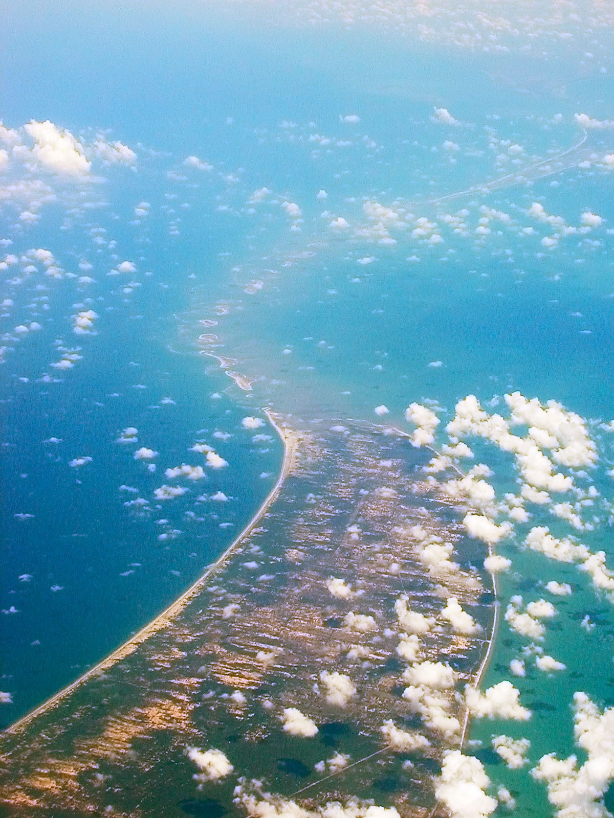
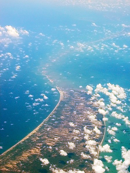
| تفصیل | Aerial view of w:Ram Setu, taken while flying over Sri Lanka looking west. | ||
| تریخ | 28 April 05 | ||
| ماخذ | اپݨا کام | ||
| مصنف |
|
||
| اجازت (فائل دا دوبارہ استعمال) |
I, the copyright holder of this work, hereby publish it under the following license: This file is licensed under the Creative Commons Attribution-Share Alike 2.5 Generic license.
|
| Camera location | | View this and other nearby images on: OpenStreetMap |
|---|
فائل دا تاریخچہ
کہیں خاص ویلے تے تریخ کوں فائل کین٘ویں نظردی ہائی، ݙیکھݨ کیتے اوں ویلے تے کلک کرو۔
| تریخ/ویلہ | تھمب نیل | پاسے | ورتݨ والا | رائے | |
|---|---|---|---|---|---|
| موجودہ | ١٥:٤٠, ٢٨ اپريل ٢٠٠٧ | | ١,٢٠٠ × ١,٦٠٠ (٤١٠ KB) | Planemad | {{Information |Description=Aerial view of w:Adam's Bridge, taken while flying over Sri Lanka looking west. |Source=own work |Date= 28 April 05 |Author= w:user:PlaneMad |Permission={{self|cc-by-sa-2.5}} |other_versions= }} [[Category:Aerial photog |
فائل ورتݨ
اِیں فائل نال ہیٹھاں درج ورقہ مربوط ہے:
فائل دا کلجگ ورتاوا
ایہ ٻئے وکی ایں فائل کوں ورتیندن:
- ar.wikipedia.org تے ورتݨ
- ast.wikipedia.org تے ورتݨ
- as.wikipedia.org تے ورتݨ
- az.wikipedia.org تے ورتݨ
- ban.wikipedia.org تے ورتݨ
- be.wikipedia.org تے ورتݨ
- bg.wikipedia.org تے ورتݨ
- bn.wikipedia.org تے ورتݨ
- br.wikipedia.org تے ورتݨ
- ca.wikipedia.org تے ورتݨ
- cs.wikipedia.org تے ورتݨ
- de.wikipedia.org تے ورتݨ
- de.wikivoyage.org تے ورتݨ
- el.wikipedia.org تے ورتݨ
- en.wikipedia.org تے ورتݨ
- en.wikiquote.org تے ورتݨ
- en.wikivoyage.org تے ورتݨ
- en.wiktionary.org تے ورتݨ
- eo.wikipedia.org تے ورتݨ
- es.wikipedia.org تے ورتݨ
- eu.wikipedia.org تے ورتݨ
- fa.wikipedia.org تے ورتݨ
- fi.wikipedia.org تے ورتݨ
- gom.wikipedia.org تے ورتݨ
- gu.wikipedia.org تے ورتݨ
- he.wikipedia.org تے ورتݨ
- hi.wikipedia.org تے ورتݨ
- hu.wikipedia.org تے ورتݨ
- hy.wikipedia.org تے ورتݨ
- id.wikipedia.org تے ورتݨ
- incubator.wikimedia.org تے ورتݨ
ایں فائل دا ٻیا جگ ورتݨ ݙیکھو.