
فائل:1864 Johnson's Map of India (Hindostan or British India) - Geographicus - India-j-64.jpg

اصل فائل (٢,٥٠٠ × ١,٩٩٠ پکسل، فائل دا حجم: ١.٦٣ MB، MIME قسم: image/jpeg)
_-_Geographicus_-_India-j-64.jpg)
| Alvin Jewett Johnson: Johnson’s Hindostan or British India.
( |
|||||||||||||||||||||||
|---|---|---|---|---|---|---|---|---|---|---|---|---|---|---|---|---|---|---|---|---|---|---|---|
| Artist |
|
||||||||||||||||||||||
| Title |
Johnson’s Hindostan or British India. |
||||||||||||||||||||||
| تفصیل |
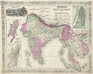
English: A very nice example of A. J. Johnson’s 1864 map of India and Southeast Asia. Covers from the Indus River eastward to include all of India, Burma, Siam (Thailand), Laos, Cambodia, Malaysia (Malacca) and Vietnam (Tonquin and Chochin). Also includes parts of Pakistan, Nepal, China, Bhutan, Sumatra and Ceylon (Sri Lanka). Offers color coding according to country and region as well as notations regarding roadways, cities, towns, and river systems. Three inset maps focus on the Island of Bombay (Mumbai), Madras, and Calcutta. An view of the Government House and Treasury in Calcutta adorns the upper left corner. Features the fretwork style border common to Johnson’s atlas work from 1864 to 1869. Published by A. J. Johnson and Ward as plate number 95 in the 1864 edition of Johnson’s New Illustrated Family Atlas. This is the last edition of the Johnson Atlas to bear the Johnson and Ward imprint, subsequent editions were attributed to Johnson exclusively. |
||||||||||||||||||||||
| تریخ | ١٨٦٤ (undated) | ||||||||||||||||||||||
| Dimensions | height: ١٣.٠ in (٣٣.٠ cm); width: ١٧.٠ in (٤٣.١ cm) | ||||||||||||||||||||||
| Accession number |
Geographicus link: India-j-64 |
||||||||||||||||||||||
| Source/Photographer |
Johnson, A. J., Johnson's New Illustrated Family Atlas of The World with Physical Geography, and with Descriptions Geographical, Statistical, and Historic including The Latest Federal Census, A Geographical Index, and a Chronological History of the Civil War in America, 1864.
|
||||||||||||||||||||||
| اجازت (فائل دا دوبارہ استعمال) |
|
||||||||||||||||||||||
فائل دا تاریخچہ
کہیں خاص ویلے تے تریخ کوں فائل کین٘ویں نظردی ہائی، ݙیکھݨ کیتے اوں ویلے تے کلک کرو۔
| تریخ/ویلہ | تھمب نیل | پاسے | ورتݨ والا | رائے | |
|---|---|---|---|---|---|
| موجودہ | ١٤:٤٤, ١٦ مارچ ٢٠١١ | | ٢,٥٠٠ × ١,٩٩٠ (١.٦٣ MB) | BotMultichill | {{subst:User:Multichill/Geographicus |link=http://www.geographicus.com/P/AntiqueMap/India-j-64 |product_name=1864 Johnson's Map of India (Hindostan or British India) |map_title=Johnson’s Hindostan or British India. |description=A very nice example of A. |
فائل ورتݨ
اِیں فائل نال ہیٹھاں درج ورقہ مربوط ہے:
فائل دا کلجگ ورتاوا
ایہ ٻئے وکی ایں فائل کوں ورتیندن:
- ar.wikipedia.org تے ورتݨ
- azb.wikipedia.org تے ورتݨ
- en.wikipedia.org تے ورتݨ
- fa.wikipedia.org تے ورتݨ
- incubator.wikimedia.org تے ورتݨ
- it.wikipedia.org تے ورتݨ
- ml.wikipedia.org تے ورتݨ
- nl.wikipedia.org تے ورتݨ
- ps.wikipedia.org تے ورتݨ
- ru.wiktionary.org تے ورتݨ
- sd.wikipedia.org تے ورتݨ
- sr.wikipedia.org تے ورتݨ
- ta.wikipedia.org تے ورتݨ
- th.wikipedia.org تے ورتݨ
- ur.wikipedia.org تے ورتݨ
- zh.wikipedia.org تے ورتݨ
_-_Geographicus_-_India-j-64.jpg)